RSHazeDiff: A Unified Fourier-aware Diffusion Model for Remote Sensing Image Dehazing
2405.09083
0
0

Abstract
Haze severely degrades the visual quality of remote sensing images and hampers the performance of automotive navigation, intelligent monitoring, and urban management. The emerging denoising diffusion probabilistic model (DDPM) exhibits the significant potential for dense haze removal with its strong generation ability. Since remote sensing images contain extensive small-scale texture structures, it is important to effectively restore image details from hazy images. However, current wisdom of DDPM fails to preserve image details and color fidelity well, limiting its dehazing capacity for remote sensing images. In this paper, we propose a novel unified Fourier-aware diffusion model for remote sensing image dehazing, termed RSHazeDiff. From a new perspective, RSHazeDiff explores the conditional DDPM to improve image quality in dense hazy scenarios, and it makes three key contributions. First, RSHazeDiff refines the training phase of diffusion process by performing noise estimation and reconstruction constraints in a coarse-to-fine fashion. Thus, it remedies the unpleasing results caused by the simple noise estimation constraint in DDPM. Second, by taking the frequency information as important prior knowledge during iterative sampling steps, RSHazeDiff can preserve more texture details and color fidelity in dehazed images. Third, we design a global compensated learning module to utilize the Fourier transform to capture the global dependency features of input images, which can effectively mitigate the effects of boundary artifacts when processing fixed-size patches. Experiments on both synthetic and real-world benchmarks validate the favorable performance of RSHazeDiff over multiple state-of-the-art methods. Source code will be released at https://github.com/jm-xiong/RSHazeDiff.
Get summaries of the top AI research delivered straight to your inbox:
Overview
- Proposes a unified Fourier-aware diffusion model called RSHazeDiff for remote sensing image dehazing
- Introduces a phased training strategy to improve performance and stabilize the training process
- Demonstrates state-of-the-art results on remote sensing dehazing benchmarks, including UAVHaze and RESIDE
Plain English Explanation
RSHazeDiff is a new AI model that can remove haze and improve the clarity of remote sensing images, such as those captured by drones or satellites. Haze can degrade the quality of these images, making it harder to see details clearly.
The key innovation in RSHazeDiff is that it uses a special "Fourier-aware" technique to process the images. Fourier analysis is a mathematical tool that can break down images into their underlying frequency components. By incorporating this Fourier-aware approach, RSHazeDiff is able to better understand and remove the haze, leading to clearer and more detailed remote sensing images.
The researchers also developed a "phased training strategy" to help the model learn more effectively. This involves training the model in stages, gradually increasing the complexity of the task. This helps stabilize the training process and leads to better performance on benchmark datasets like UAVHaze and RESIDE.
Overall, RSHazeDiff represents an important advance in the field of remote sensing image dehazing, with the potential to improve a wide range of applications that rely on high-quality aerial and satellite imagery.
Technical Explanation
RSHazeDiff is a unified Fourier-aware diffusion model for remote sensing image dehazing. Diffusion models have shown promising results for image restoration tasks, but they have not been extensively explored for remote sensing dehazing applications.
The key innovation in RSHazeDiff is the incorporation of Fourier-aware refinement, which allows the model to better understand and remove the haze in remote sensing images. By analyzing the frequency components of the images using Fourier analysis, the model can more effectively identify and target the haze-related frequencies, leading to improved dehazing performance.
The researchers also introduce a phased training strategy to stabilize the training process and boost the model's performance. This involves training the model in stages, starting with simple dehazing tasks and gradually increasing the complexity. This helps the model learn more effectively and achieve state-of-the-art results on benchmark datasets like UAVHaze and RESIDE.
Critical Analysis
The paper presents a compelling approach to remote sensing image dehazing, but there are a few areas that could be explored further:
-
Generalization to other remote sensing modalities: The paper focuses on RGB imagery, but it would be interesting to see how the Fourier-aware diffusion model performs on other remote sensing data types, such as SAR imagery.
-
Explainability and interpretability: While the Fourier-aware refinement mechanism is a key innovation, the paper does not provide detailed insights into how the model is leveraging the Fourier domain information to improve dehazing. Enhancing the interpretability of the model could lead to further advancements.
-
Computational efficiency: Diffusion models can be computationally intensive, which may limit their practical deployment in real-world remote sensing applications. Exploring techniques to improve the efficiency of RSHazeDiff would be a valuable next step.
Overall, the RSHazeDiff model represents an important advancement in the field of remote sensing image dehazing, and the researchers have demonstrated its strong performance on benchmark datasets. Continued exploration of the model's capabilities and potential limitations could lead to further improvements and broader applicability.
Conclusion
RSHazeDiff is a novel Fourier-aware diffusion model that advances the state-of-the-art in remote sensing image dehazing. By incorporating Fourier analysis into the model's architecture and training process, the researchers have developed a powerful tool for enhancing the clarity and quality of remote sensing imagery.
The phased training strategy and strong benchmark results highlight the potential of RSHazeDiff to improve a wide range of applications that rely on high-quality aerial and satellite imagery, such as urban planning, disaster response, and environmental monitoring. As the field of remote sensing continues to evolve, innovative approaches like RSHazeDiff will be crucial for unlocking the full potential of these valuable data sources.
This summary was produced with help from an AI and may contain inaccuracies - check out the links to read the original source documents!
Related Papers
🖼️
High-quality Image Dehazing with Diffusion Model
Hu Yu, Jie Huang, Kaiwen Zheng, Feng Zhao
0
0
Image dehazing is quite challenging in dense-haze scenarios, where quite less original information remains in the hazy image. Though previous methods have made marvelous progress, they still suffer from information loss in content and color in dense-haze scenarios. The recently emerged Denoising Diffusion Probabilistic Model (DDPM) exhibits strong generation ability, showing potential for solving this problem. However, DDPM fails to consider the physics property of dehazing task, limiting its information completion capacity. In this work, we propose DehazeDDPM: A DDPM-based and physics-aware image dehazing framework that applies to complex hazy scenarios. Specifically, DehazeDDPM works in two stages. The former stage physically models the dehazing task with the Atmospheric Scattering Model (ASM), pulling the distribution closer to the clear data and endowing DehazeDDPM with fog-aware ability. The latter stage exploits the strong generation ability of DDPM to compensate for the haze-induced huge information loss, by working in conjunction with the physical modelling. Extensive experiments demonstrate that our method attains state-of-the-art performance on both synthetic and real-world hazy datasets.
4/16/2024
Remote Diffusion
Kunal Sunil Kasodekar
0
0
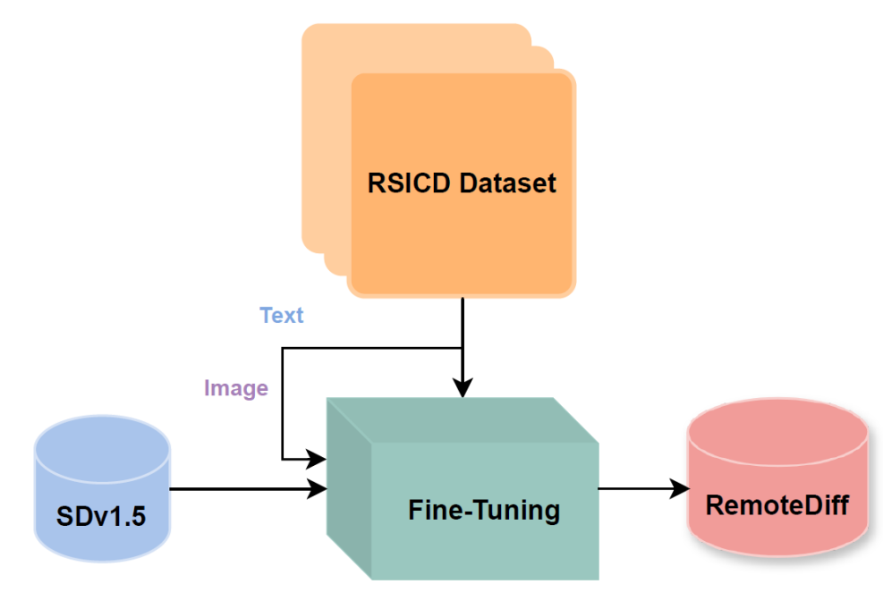
I explored adapting Stable Diffusion v1.5 for generating domain-specific satellite and aerial images in remote sensing. Recognizing the limitations of existing models like Midjourney and Stable Diffusion, trained primarily on natural RGB images and lacking context for remote sensing, I used the RSICD dataset to train a Stable Diffusion model with a loss of 0.2. I incorporated descriptive captions from the dataset for text-conditioning. Additionally, I created a synthetic dataset for a Land Use Land Classification (LULC) task, employing prompting techniques with RAG and ChatGPT and fine-tuning a specialized remote sensing LLM. However, I faced challenges with prompt quality and model performance. I trained a classification model (ResNet18) on the synthetic dataset achieving 49.48% test accuracy in TorchGeo to create a baseline. Quantitative evaluation through FID scores and qualitative feedback from domain experts assessed the realism and quality of the generated images and dataset. Despite extensive fine-tuning and dataset iterations, results indicated subpar image quality and realism, as indicated by high FID scores and domain-expert evaluation. These findings call attention to the potential of diffusion models in remote sensing while highlighting significant challenges related to insufficient pretraining data and computational resources.
5/9/2024
🤿
Dehazing Remote Sensing and UAV Imagery: A Review of Deep Learning, Prior-based, and Hybrid Approaches
Gao Yu Lee, Jinkuan Chen, Tanmoy Dam, Md Meftahul Ferdaus, Daniel Puiu Poenar, Vu N Duong
0
0
High-quality images are crucial in remote sensing and UAV applications, but atmospheric haze can severely degrade image quality, making image dehazing a critical research area. Since the introduction of deep convolutional neural networks, numerous approaches have been proposed, and even more have emerged with the development of vision transformers and contrastive/few-shot learning. Simultaneously, papers describing dehazing architectures applicable to various Remote Sensing (RS) domains are also being published. This review goes beyond the traditional focus on benchmarked haze datasets, as we also explore the application of dehazing techniques to remote sensing and UAV datasets, providing a comprehensive overview of both deep learning and prior-based approaches in these domains. We identify key challenges, including the lack of large-scale RS datasets and the need for more robust evaluation metrics, and outline potential solutions and future research directions to address them. This review is the first, to our knowledge, to provide comprehensive discussions on both existing and very recent dehazing approaches (as of 2024) on benchmarked and RS datasets, including UAV-based imagery.
5/14/2024

Resfusion: Denoising Diffusion Probabilistic Models for Image Restoration Based on Prior Residual Noise
Zhenning Shi, Haoshuai Zheng, Chen Xu, Changsheng Dong, Bin Pan, Xueshuo Xie, Along He, Tao Li, Huazhu Fu
0
0
Recently, research on denoising diffusion models has expanded its application to the field of image restoration. Traditional diffusion-based image restoration methods utilize degraded images as conditional input to effectively guide the reverse generation process, without modifying the original denoising diffusion process. However, since the degraded images already include low-frequency information, starting from Gaussian white noise will result in increased sampling steps. We propose Resfusion, a general framework that incorporates the residual term into the diffusion forward process, starting the reverse process directly from the noisy degraded images. The form of our inference process is consistent with the DDPM. We introduced a weighted residual noise, named resnoise, as the prediction target and explicitly provide the quantitative relationship between the residual term and the noise term in resnoise. By leveraging a smooth equivalence transformation, Resfusion determine the optimal acceleration step and maintains the integrity of existing noise schedules, unifying the training and inference processes. The experimental results demonstrate that Resfusion exhibits competitive performance on ISTD dataset, LOL dataset and Raindrop dataset with only five sampling steps. Furthermore, Resfusion can be easily applied to image generation and emerges with strong versatility. Our code and model are available at https://github.com/nkicsl/Resfusion.
5/21/2024